Synopsis:
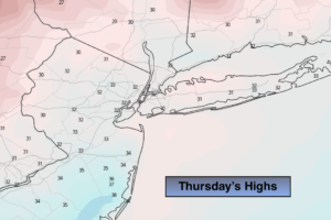
Today will be bright and seasonal as strong high pressure moves overhead. The average high temperatures are in the upper 30s.
On Friday the high pressure system will move off the coast. A return Southwesterly flow will cause readings to rise to well above the average highs. Clouds will dominate. Spring-like readings are expected both Saturday and Sunday. It’ll feel more like mid to late April then the dead of Winter. Spotty showers are possible on Saturday. Steadier rain is likely either Saturday night or Sunday morning with an approaching cool front. The record high for Saturday, January 11th is 63º. Record high temperatures will be in jeopardy.
Even with a cool frontal passage on Monday readings will be almost ten degrees above average.
It will be some time until we experience an Arctic blast or a decent snow event. The weather pattern is horrible for Winter conditions. Sorry snow lovers.
Stay Tuned.
Keep it here for a no hype, no nonsense forecast.
Today:
Sunny and seasonal. Highs in the mid to upper 30s. Northwest to Southeast winds at 5mph.
Tonight:
Becoming mostly cloudy. Lows in the lower 30s in the City, the 20s inland. South to Southwest winds at 5-10mph.
Friday:
Mostly cloudy. Much milder. Highs around 50º.
Saturday:
Mostly cloudy and warm with spotty showers. Highs in the lower to mid 60s.
Sunday:
Mostly cloudy and warm with a period of rain likely in the morning. Highs in the lower to mid 60s.
Monday:
Mostly sunny. Highs in the mid to upper 40s.