Synopsis:
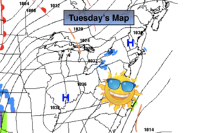
Tranquil weather will continue for the week. Cold conditions will greet us today as extensive high pressure dominates the Eastern half of the country. Readings will be near seasonal levels, in the upper 30s, on Wednesday.
A warmup will occur late week as the high moves off the coast and a warmer Southwest flow develops.
A broad area of low pressure will develop over the Ohio Valley and the Southern Mid-Atlantic on Saturday. The potential exists for rain along the coast and a mix of snow, sleet and rain inland. Specifics this far out are nearly impossible. There is only marginally cold air available and the storm track has yet to be determined.
Stay Tuned.
Keep it here for a no hype, no nonsense forecast.
Today:
Sunny and cold. Highs in the lower to mid 30s. Northwest winds at 5-10mph.
Tonight:
Clear and cold. Lows in the mid 20s in the City, the teens inland. Northwest winds at 5mph or less.
Wednesday:
Sunny, seasonal. Highs in the upper 30s.
Thursday:
Sunny. Milder. Highs in the mid 40s.
Friday:
Mostly sunny. Highs in the mid 40s.
Saturday:
Rain. Snow, sleet and rain inland. Highs in the mid to upper 30s.