Synopsis:
Tranquil weather will continue for the week as extensive high pressure dominates the Eastern half of the country. Readings will be near seasonal levels, in the upper 30s today.
A warmup will occur late week as the high moves off the coast and a warmer Southwest flow develops.
A broad area of low pressure will develop over the Ohio Valley and the Southern Mid-Atlantic on Saturday. As these lows move to the Northeast one main storm will form over the area. There is only marginally cold air available so most of the precipitation will be rain. Inland, a mix of snow, sleet and rain is likely. The potential is there well North and West and especially over the higher elevations of some accumulation.
On the backside of the storm on Sunday skies will be mostly cloudy with scattered rain and or snow showers.
Stay Tuned.
Keep it here for a no hype, no nonsense forecast.
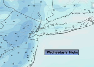
Today:
Sunny, seasonal. Highs in the upper 30s. North to Southwest winds less than 5mph.
Tonight:
Clear. Lows around freezing in the City, the 20s and teens inland. Southwest winds at 5mph or less.
Thursday:
Sunny. Milder. Highs in the mid 40s.
Friday:
Mostly sunny. Highs in the mid 40s.
Saturday:
Rain. Snow, sleet and rain well inland. Highs in the mid to upper 30s.
Sunday:
Mostly cloudy with scattered rain and or snow showers. Highs in the lower 40s.