Synopsis:
Tranquil weather will continue through Friday as high pressure moves off the Eastern seaboard. A warmup will occur with a Southwest wind. Temperatures will be above the average high of the upper 30s. Today will be party sunny. By Friday more clouds will work into the region with moisture building in from the South and West.
A broad area of low pressure will develop over the Ohio Valley and the Southern Mid-Atlantic on Saturday. As these lows move to the Northeast one main storm will form over the area. There is only marginally cold air available so most of the precipitation will be rain. If any snow falls with this system it’ll be at the highest elevations of extreme Northwestern NJ and the Catskill, another yawn for snow lovers.
On the backside of the storm on Sunday skies will be mostly cloudy with scattered rain and or snow showers.
Tranquil conditions will greet us for the beginning of the workweek with above average readings continuing.
Stay Tuned.
Keep it here for a no hype, no nonsense forecast.
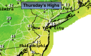
Today:
Partly sunny. Milder. Highs in the mid 40s. Southwest winds at 5mph.
Tonight:
Party cloudy. Lows in the mid 30s in the City, the 20s inland. Light and variable winds.
Friday:
More clouds than sun Mild. Highs in the mid to upper 40s.
Saturday:
Rain. Highs in the lower to mid 40s.
Sunday:
Mostly cloudy with scattered rain and or snow showers. Highs in the lower 40s.
Monday:
Mostly sunny. Mild. Highs in the mid 40s.