Synopsis:
Tranquil weather will close out the week as high pressure moves off the Eastern seaboard. Temperatures will be at least ten degrees above the average high of 38º. A mix of clouds and sun is expected for today.
Increasing clouds are expected tonight as moisture works in from the South and West.
A broad area of low pressure will develop over the Ohio Valley and the Southern Mid-Atlantic on Saturday. As these lows move to the Northeast one main storm will form over the area. This is a warm solution, meaning rain and not snow. The rain could be heavy at times Saturday with over an inch possible by evening.
The better half of the weekend will be Sunday. A mix of sun and clouds is expected with readings still above average.
Tranquil conditions will greet us for the beginning of the workweek with mild temperatures as we head through late January-our coldest time of the year climatologically.
Stay Tuned.
Keep it here for a no hype, no nonsense forecast.
Today:
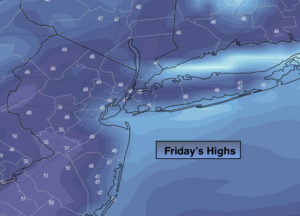
Times of clouds and sun. Mild. Highs in the mid to upper 40s. Northeast to East winds at 5-10mph.
Tonight:
Increasing clouds. Lows in the mid 30s in the City, around 30º inland. East to Northeast winds at 8-12mph.
Saturday:
Rain. The rain will be heavy at times. Highs in the mid 40s.
Sunday:
Clouds and sun. Breezy. Highs in the mid 40s.
Monday:
Partly sunny. Mild. Highs in the mid 40s.
Tuesday:
Partly sunny. Highs in the lower 40s.