Synopsis:
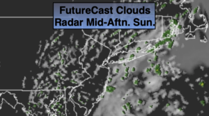
The first weekend of October will be bright and cool as high pressure influences the area from Canada. Today will be spectacular with abundant sunshine. Sunday will start off with sun but clouds will roll in during the afternoon. Readings will be a few degrees below the average high of 69º.
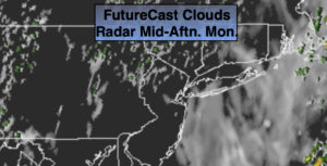
Low pressure will develop off the Mid-Atlantic coast on Monday and move Northeast. A mix of clouds and sun is expected with a few showers. This will not be a big rain producer as the system develops too late and is too far offshore.
Tuesday and Wednesday will be Fall classics with abundant sunshine and near seasonal readings.
Stay Tuned.
Keep it here for a no nonsense, no hype forecast.
Today:
Mostly sunny. Cool. Highs in the mid 60s. Northwest winds at 5-10mph.
Tonight:
Clear and chilly. Lows near 50º in the City, the 30s and 4os inland. North wind at 5mph.
Sunday:
Sun to afternoon clouds. Highs in the mid 60s.
Monday:
Clouds and sun. Scattered showers. Highs in the mid 60s.
Tuesday:
Mostly sunny. Highs in the upper 60s.
Wednesday:
Partly sunny. Mild.. Highs in the lower 70s.