
Synopsis:
High pressure will move off the East coast Sunday continuing our “Fall Classic” Weekend.
Scattered Frost is possible North and West tonight with lows near freezing in some spots. A Frost Advisory has been posted (map above).
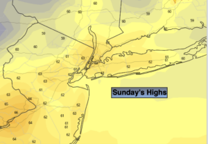
Sunday temperatures will reach seasonal levels-the lower 60s. The sun will dominate with a few high clouds rolling in during the afternoon.
The extended forecast looks bright and mild as high pressure continues to influence our weather.
Some fine October conditions for sure!
Stay Tuned.
Keep it here for a no nonsense, no hype forecast.
Tonight:
Clear and chilly. Scattered frost North and West. Lows in the mid to upper 40s in the urban corridor. Near 30º-35º well inland. Light and variable winds.
Sunday:
Sunny, more seasonal. Highs in the lower 60s. Southeast winds at 5-10mph.
Monday:
Partly sunny. Highs in the mid 60s.
Tuesday:
Partly sunny. Highs in the mid to upper 60s.
Wednesday:
Partly sunny. Warm. Highs near 70º.
Thursday:
Partly sunny. Highs near 70º.