Synopsis:
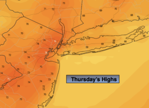
Today will be a “Fall Classic” with abundant sunshine and warm readings as high pressure moves off the coast.
Clouds will thicken tonight with the next system approaching from the West.
A cold front will move into the region on Friday. Scattered showers will turn into a steadier rain later in the day. It will be chilly. Low pressure will be developing along the front Friday evening and night. This will enhance the rainfall along the coast and to the East.
The front will move off the coast early Saturday morning resulting in a mostly sunny day . There will be a nip in the air.
Sunday looks bright and seasonal as high pressure moves in.
Stay Tuned.
Keep it here for a no nonsense, no hype forecast.
Today:
Sunny and warm. Highs in the lower mid 70s. Cooler at the coast. South to Southwest winds at 8-12mph.
Tonight:
Thickening clouds. Lows mainly in the lower to mid 50s. Southwest to Northwest winds at 5mph.
Friday:
Scattered morning showers becoming a steadier rain later in the day. Much cooler.. Highs in the upper 50s.
Saturday:
Mostly sunny. Chilly. Highs in the upper 50s.
Sunday:
Sunny, more seasonal. Highs in the lower 60s.
Monday:
Mostly sunny. Highs in the mid 60s.