Synopsis:
Low pressure over the Central Appalachians today will begin to move toward the region. Sunshine will give way to late afternoon clouds. Clouds will thicken tonight but it will remain dry.
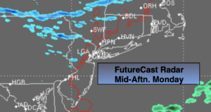
As the low moves just to our South it will throw on and off light snow or snow showers our way for Tuesday. On and off light sleet, freezing rain mixed with the snow will likely occur in the NYC vicinity and to the South. Central and Southern NJ will mainly experience rain.. This system will basically fall apart over the region so a big snow will not happen. A coating of snow is likely in areas where snow is the predominate type of precipitation. No accumulation is expected over Southern areas.
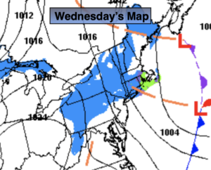
Early morning showers of mixed precipitation and snow showers will give way to some sun as the weak system pulls off our coast on Wednesday.
All eyes then turn to a developing Carolina storm on Wednesday night and Thursday. The computer models are in good agreement that this storm will intensify rapidly and move off the Virginia coast and not up the coast, sparing the region of snow. It will be windy and cold as the storm cranks offshore Thursday. A mix of sun and clouds is expected.
Behind the Atlantic storm, Arctic high pressure will funnel in the coldest air of the season so far on Friday. Mainly sunny skies are expected with a biting wind.
Stay Tuned.
Keep it here for a no nonsense, no hype forecast.
Today:
Sun giving way to late day clouds. Highs in the mid 30s. Northwest winds at 5-10mph.
Tonight:
Thickening clouds. Lows around 30º in the City, teens and 20s inland. Northeast winds at 5mph.
Tuesday:
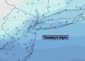
Occasional light snow or snow showers developing. Light on and off sleet, freezing rain and rain for areas near and South of the City. Highs in the 30s.
Wednesday:
Early morning snow showers or mixed precipitation. Mostly cloudy. Highs in the mid 30s.
Thursday:
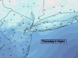
Sun and clouds, windy and cold. Highs in the mid 30s.
Friday:
Partly sunny, windy and very cold. Highs only in the upper 20s.