Synopsis:
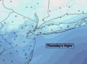
Low pressure will move across Southern Canada and into the Atlantic as high pressure moves across the Southeast through Friday. Readings will be a couple of degrees above the average high of 38º under a mix of sun and clouds.
Strong high pressure over Canada will influence our weather this weekend. Sunny skies are expected with below average temperatures. Saturday the wind will add a bite. Sunday will be more tranquil.
Looking ahead, computer models are in a state of disarray. Low pressure will be over the Central Appalachians whether it slides to our South or affects our weather remains to be seen. A low potential for late day snow is in the forecast for Monday.
Stay Tuned.
Keep it here for a no nonsense, no hype forecast.
Today:
Clouds and sun. Highs around 40º. Southwest to West winds at 8-12mph.
Tonight:
Partly cloudy. Lows in the mid 30s in the City, the 20s inland. West winds at 5-10mph.
Friday:
Partly sunny. Highs in the lower 40s.
Saturday:
Mostly sunny. Windy. Highs around freezing. Wind chills in the 20s.
Sunday:
Sunny. Highs in the lower to mid 30s.
Monday:
Increasing clouds. Low potential of late day or evening snow. Highs in the mid 30s.