Synopsis:
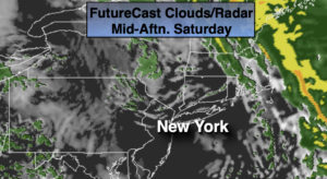
Rain will end this morning over Eastern sections as low pressure continues to move North into New England. A mix of sun and clouds is expected during the day. Mild conditions will persist. Spotty showers are possible just about any time as the upper level energy rotates through.
Partly cloudy skies are expected tonight. Readings will be above average for a January night but the breeze will make it feel colder.
Sunday will be dry, but chilly with a gusty wind behind the departing and intensifying storm over Southeastern Canada.
MLK day and Tuesday will be chilly under a mix of sun and clouds. Readings will be around or just above seasonal averages as high pressure settles over the Southeast.
Looking down the pike, the jet stream is in a zonal flow. This results in little in the way of storm formation- meaning the wait for a decent snow continues.
Stay Tuned.
Keep it here for a no nonsense, no hype forecast.
Today:
Early morning rain east, otherwise a mix of sun and clouds. A few spotty showers are possible. Mild. Highs in the mid to upper 40s. West to Northwest winds increasing to 15-25mph.
Tonight:
Partly cloudy and breezy. Lows in the mid 30s in the City, the upper 20s to lower 30s inland. West winds at 10-20mph.
Sunday:
Sun and clouds. Windy. Highs in the lower to mid 40s.
Monday (The Reverend Dr. Martin Luther King Jr. Day):
Sun and clouds. Breezy. Highs around 40º.
Tuesday:
Mostly sunny. Breezy and seasonal. Highs in the upper 30s.
Wednesday:
Partly sunny. Highs in the mid to upper 30s.