Synopsis:
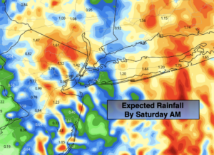
Rain will fall overnight. It will be heavy at times as a cool front moves over the region and low pressure develops along the front. An axis of heavy rain is likely to set up over parts of Long Island and Connecticut late tonight. The only regions that may see wet snow accumulate is the Catskills and possibly the Poconos.
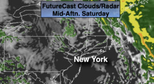
Rain will end early Saturday morning. A mix of sun and clouds is expected during the day. Mild conditions will persist. Spotty showers are possible during the afternoon as the upper level energy rotates through.
Sunday will be dry, but chilly with a gusty wind behind the departing and intensifying storm over Southeastern Canada.
MLK day and Tuesday will be chilly under a mix of sun and clouds. Readings will be around or just above seasonal averages as high pressure settles over the Southeast.
There is still no significant snow in the foreseeable future.
Stay Tuned.
Keep it here for a no nonsense, no hype forecast.
Tonight:
Rain. Heavy at times, especially East of the City. Lows in the 40s in the City, the 30s inland. East winds at 10-20mph with higher gusts.
Saturday:
Early morning rain, otherwise a mix of sun and clouds. A few spotty afternoon showers are possible. Mild. Highs in the mid to upper 40s. West to Northwest winds increasing to 15-25mph.
Sunday:
Sun and clouds. Windy. Highs in the lower to mid 40s.
Monday (The Reverend Dr. Martin Luther King Jr. Day):
Sun and clouds. Breezy. Highs around 40º.
Tuesday:
Mostly sunny. Breezy and seasonal. Highs in the upper 30s.
Wednesday:
Partly sunny. Highs in the mid to upper 30s.