Synopsis:
A very mild airmass encompasses much of the Eastern one half of the nation. The Arctic air is banked up in Canada. It won’t be feeling like January the next few days. Readings will be well above the average high of 38º.
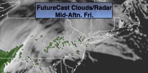
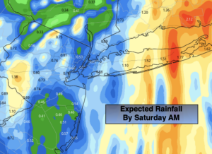
Skies will be grey today as a cool front approaches (a bit of filtered sun is possible this morning). A few light spotty showers will develop during the afternoon. A period of rain is likely with the front tonight into a part of Saturday. Low pressure will develop along the front, enhancing the rainfall. In fact, an axis of heavy rain is likely to set up over parts of Long Island and Connecticut. Any wet snow will be confined to areas well to the North and West (not a big deal).
Rain will end early Saturday morning. A mix of sun and clouds is expected during the day. Mild conditions will persist. Sunday will be dry, but chilly with a gusty wind behind the departing and intensifying storm over Southeastern Canada.
MLK day and Tuesday will be chilly under a mix of sun and clouds. Readings will be around or just above seasonal averages as high pressure settles over the Southeast.
There is still no significant snow in the foreseeable future.
Stay Tuned.
Keep it here for a no nonsense, no hype forecast.
Today:
Mainly Cloudy. Spotty afternoon showers. Mild. Highs in the upper 40s. Northeast to East winds at 10-15mph.
Tonight:
Rain developing this evening and continuing overnight. Lows in the 40s in the City, the 30s inland. East winds at 10-20mph with higher gusts.
Saturday:
Early morning rain, otherwise a mix of sun and clouds. Mild. Highs in the mid to upper 40s.
Sunday:
Sun and clouds. Windy. Highs in the lower 40s.
Monday (The Reverend Dr. Martin Luther King Jr. Day):
Sun and clouds. Breezy. Highs around 40º.
Tuesday:
Mostly sunny. Breezy and seasonal. Highs in the upper 30s.