Synopsis:
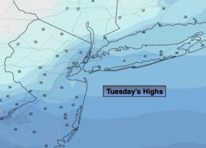
Today will be chilly under a mix of sun and clouds. The wind will continue to be of notice. Readings will be around or just above seasonal averages as high pressure settles over the Southeast. The average high is 38º.
A cold front will swing though Wednesday. High temperatures will occur early in the day. Readings will fall through the 30s during the afternoon as Canadian air moves. Scattered flurries are possible.
A weak disturbance will move through Thursday with more clouds.
Friday will be tranquil with tolerable temperatures.
Strong high pressure over Canada will begin to influence our weather this weekend. Sunny skies are expected with below average temperatures.
Stay Tuned.
Keep it here for a no nonsense, no hype forecast.
Today:
Partly sunny. Breezy. Highs in the lower 40s. West winds at 10-20mph.
Tonight:
Partly cloudy. Lows around freezing in the City, the 20s inland. West winds at 8-12mph.
Wednesday:
Partly sunny, breezy and turning colder. Scattered flurries are possible. Early high around 40º with readings falling through the 30s during the day.
Thursday:
Mostly cloudy. Highs in the upper 30s.
Friday:
Partly sunny. Highs in the lower 40s.
Saturday:
Mostly sunny. Highs in the mid 30s.