Synopsis:
Today will feature relief from the oppressive conditions as weak cool front has pushed the heat bubble into the Atlantic. Temperatures will still flirt with 90º but this is several degrees cooler than the last few days and it will be significantly less humid. If 90º is achieved this will be day 5 of the heat wave. Abundant sunshine is expected.
No major weather systems will affect the region; basically what you see is what you get. The wind will veer to the South on Friday and into the weekend. This will bring up the humidity once again. Hazy skies are expected. A spotty storm can’t be ruled out as we turn the page to August. Wow, did I say August?
Stay Tuned.
Keep it here for a no nonsense, no hype forecast.
Today:
Mostly sunny, not as hot or humid. Highs in the upper 80s to around 90º. Winds becoming South at 5-10mph.
Tonight:
Mostly clear. Lows in the mid 70s in urban areas, the 60s inland. Winds becoming South at less than 5mph.
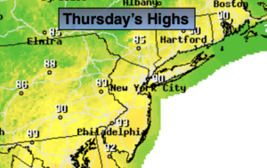
Thursday:
Mostly sunny. Hot. Highs around 90º.
Friday:
Partly sunny. Highs in the upper 80s.
Saturday:
Partly sunny. More humid. Highs in the upper 80s.
Sunday:
Hazy, warm and humid. Chance of a spotty storm. Highs in the mid to upper 80s.