Synopsis:
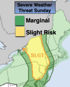
A push of tropical air from the South today along with a few disturbances riding along the jet stream will cause two scattered rounds of thunderstorms. One round this morning will mainly be concentrated over the Northern half of the tri-state area. The second threat will be for the entire region later this afternoon.
The airmass will be very unstable so any storm may become severe. Severe thunderstorms contain winds in excess of 58mph and or one inch hail. Frequent cloud to ground lightning and torrential rain will also be a concern. An isolated tornado cannot be ruled out. I know this sounds like today will be a washout out but it won’t. There will be several hours of tranquil weather and hazy sun at times. Please keep an eye to the sky for threatening weather this morning and then again later this afternoon.
Any leftover evening storms will give way to partly cloudy skies tonight. It will be warm and muggy.
Monday will feature more sunshine as a Bermuda high noses in from the Western Atlantic. This will result in readings flirting with 90º. A spotty afternoon storm is possible.
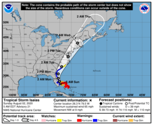
All eyes then turn to Tropical Storm Isaias. The storm will ride along the Florida coast today. Isaias will continue North to just off the Georgia coast Monday afternoon and is forecast to make landfall Monday night along the South Carolina coast. Isaias will ride inland just and take East of the I-95 corridor and affect our weather on Tuesday and Tuesday night. Confidence continues to increase that a round of heavy rain and gusty winds will occur. Flooding is quite likely in vulnerable areas. 2″-5″+ of rain is possible. Tropical storm force winds are possible along the coast. This will be fine-tuned as we get closer to the event.
The storm will move out of the area on Wednesday and the sun will return.
Stay Tuned.
Keep it here for a no nonsense, no hype forecast.
Today:
Mostly cloudy with spotty showers and storms in the morning. Some hazy afternoon sun with scattered storms. Some of the storms maybe severe. Very humid. Highs in the upper 80s. Cooler along the coast. Southeast winds at 10-20mph.
Tonight:
A leftover evening shower or storm, otherwise partly cloudy. Warm and muggy. Lows in the upper 70s in urban areas, near 70º inland. Southwest to West wind less than 5-10mph.
Monday:
Hazy, warm and humid. Chance of afternoon scattered showers and storms. Highs around 90º.
Tuesday:
Potential for area of heavy rain and gusty winds by afternoon. Tropical. Highs in the upper 70s.
Wednesday:
Partly sunny. Highs in the mid 80s.
Thursday:
Partly sunny. Highs in the mid 80s.