Synopsis:
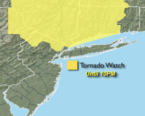
A Tornado Watch is in effect until 10pm for Sussex, Passaic and Bergen counties in NJ, All of the lower Hudson Valley and most of Connecticut. The watch doesn’t include NYC, Long Island and areas to the South. Scattered thunderstorms may become severe this evening. An isolated severe storm has the capability of producing a weak tornado. Please seek shelter if threatening weather approaches. Not all areas will get in on the action.
Any leftover evening storms will give way to partly cloudy skies tonight. It will be warm and muggy.
Monday will feature more sunshine as a Bermuda high noses in from the Western Atlantic. This will result in readings flirting with 90º. A spotty afternoon storm is possible.
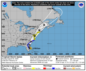
All eyes then turn to Tropical Storm Isaias. The storm will ride along the Florida through tonight. Isaias will continue North to just off the Georgia coast Monday afternoon and is forecast to make landfall Monday night along the South Carolina coast. Isaias will ride inland just East of the I-95 corridor and affect our weather on Tuesday and Tuesday night. Confidence continues to increase that a round of heavy rain and gusty winds will occur. Flooding is quite likely in vulnerable areas. A Flash Flood watch has been posted for Tuesday. 2″-5″+ of rain is possible. A Tropical Storm Watch has been issued much of the area, except for the Northwestern counties. Winds may gust between 45-60mph. Coastal Flooding may become an issue depending on location and the exact track of Isaias.
The storm will move out of the area on Wednesday and the sun will return.
Stay Tuned.
Keep it here for a no nonsense, no hype forecast.
This Evening:
Scattered showers and storms. Some of the storms maybe severe. It will be very humid.
Tonight:
A leftover evening shower or storm, otherwise partly cloudy. Warm and muggy. Lows in the upper 70s in urban areas, near 70º inland. Southwest to West wind less than 5-10mph.
Monday:
Hazy, warm and humid. Chance of afternoon scattered showers and storms. Highs around 90º.
Tuesday:
Potential for area of heavy rain and gusty winds by afternoon. Tropical. Highs in the upper 70s.
Wednesday:
Partly sunny. Highs in the mid 80s.
Thursday:
Partly sunny. Highs in the mid 80s.