Synopsis:
If 90º is achieved today this will be day 6 of the heat wave. A mix of sun and clouds is expected. The humidity will be at a moderate level.
An upper level disturbance will move through the region tonight and Friday morning with scattered showers and isolated storms. Local downpours are possible. Friday will be much cooler due to the rain-cooled air and clouds.
As we turn the page to August this weekend the humidity will return. Hazy skies are expected both days. It will warm and mainly dry. Spotty storms are possible on Sunday.
All eyes then turn to Tropical Storm Isaias. The storm will head over Hispaniola later today and then into the Bahamas Friday and Saturday. Where it goes from there is still uncertain. The storm will head North. Will it be into Florida or stay offshore? From there the track will be up the coast-inland, along the coast or offshore? The track will determine what conditions will occur in the tri-state area. Most likely timeframe Tuesday.
Stay Tuned.
Keep it here for a no nonsense, no hype forecast.
Today:
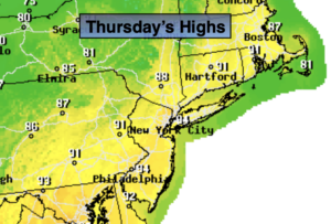
Partly sunny. Hot. Highs around 90º. Cooler at the coast. Southwest winds at 8-12mph.
Tonight:
Mostly cloudy with scattered showers and storms late. Locally heavy downpours are possible. Lows in the lower 70s in urban areas, the 60s inland. Winds becoming North at less than 5mph.
Friday:
Scattered showers and storms during the morning. Some afternoon sun. Cooler. Highs in the lower 80s.
Saturday:
Partly sunny. More humid. Highs in the mid to upper 80s.
Sunday:
Hazy, warm and humid. Chance of a spotty storm. Highs in the mid to upper 80s.
Monday:
Hazy, warm and humid. Chance of scattered showers and storms. Highs in the mid 80s.