Synopsis:
A cold front pushed through the area early this morning. Temperatures started out in the 50s to around 60º! The mercury will fall through the 50s and into the 40s through the day. Winds will be strong gusting up to 45mph at times out of the West to Northwest.
High pressure will build into the East coast tonight and Monday resulting in cold readings. The return flow around the high will cause temperatures to once again spike into the 5os Tuesday and Wednesday.
The rollercoaster ride in temperatures will continue as a cold front moves Through Wednesday night. Thanksgiving will be colder under mostly sunny skies with highs only in the 40s.
No major storms are on the map for the rest of the holiday weekend.
Stay tuned.
Today:
Early morning showers East, otherwise, partly sunny. Windy. Highs in the 50s during the morning. Temperatures will fall into the 40s during the afternoon. West to Northwest winds at 15-25mph with gusts to 45mph.
Tonight:
Partly cloudy, breezy and cold. Lows in the mid 30s in the City the upper 20s to around freezing inland. West to Northwest winds at 15-25mph with higher gusts.
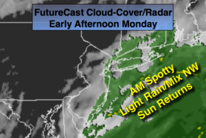
Monday:
Partly sunny, breezy and chilly. Highs in the mid 40s.
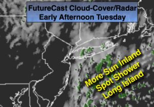
Tuesday:
Mostly sunny, milder. Highs in the lower to mid 50s.
Wednesday:
Partly sunny. Highs in the lower 50s.
Thanksgiving:
Partly sunny. Highs in the upper 40s.
Keep it here for a no nonsense, no hype forecast.