Synopsis:
High pressure will move in today bringing with it cooler and sunny conditions. Winds will be busy, but begin to diminish during the afternoon.
The high will slip offshore Saturday. The return flow will pump up mild air from the South. A cold front will approach during the afternoon with any sun giving way to showers by afternoon. Saturday will to be a washout. In fact, much of the day should be dry. The showers will continue Saturday night and into Sunday Morning. The sun should return Sunday afternoon. It’ll be windy and mild.
Looking down the pike into Thanksgiving week it looks tranquil through Thanksgiving with the rollercoaster ride in temperatures continuing.
Stay tuned.
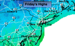
Today:
Mostly sunny, breezy and cool. Highs in the upper 40s. Northwest winds at 15-25mph and diminishing during the afternoon.
Tonight:
Partly cloudy. Lows around 40º in the City, the 20s inland. Northwest to Southwest winds less then 5mph.
Saturday:
Morning sun will give way to scattered afternoon showers. Mild. Highs in the mid to upper 50s.
Sunday:
Morning showers will give way to afternoon sun. Highs in the 50s during the morning. Temperatures will fall into the 40s by sunset.
Monday:
Partly sunny, cooler. Highs in the lower to mid 40s.
Tuesday:
Mostly sunny, milder. Highs in the lower 50s.
Keep it here for a no nonsense, no hype forecast.