Synopsis:
The bitter blast will be with us until further notice as the gates are open for Arctic air to spill into the nation as strong high pressure continues to move in from Canada. Readings will be well below freezing through the shortened workweek.
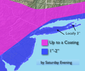
I am keeping an eye on a Western Atlantic storm for Wednesday Night through Thursday. The latest computer models have it to the East of a favorable track for significant snow but just close enough for a potential for “some snow” for most of the tri-state area. A shift more toward the coast would mean a greater potential of snow for all areas. A shift to the East, no snow. There will be a trough of low pressure extending out from the storm toward the coast. If this feature develops and moves over the region the potential for snow will increase for most areas. The highest snow totals will be at the coast with little in the way of accumulation well inland. A possible snow amounts map will be out by this afternoon.
Whatever the outcome with the ocean storm, the coldest air of the season will usher in Friday. Highs will struggle to get to 10º.
Stay tuned.
Today:
Mostly sunny and cold Highs in the lower to mid 20s. West wind at 8-12mph.
Tonight:
Clear and frigid. Lows in the mid teens in the City, near 0º to 10º inland. West to Northwest winds at 8-12mph.
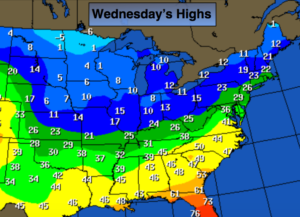
Wednesday:
Partly sunny and cold Highs in the upper 20s.
Thursday:
Mostly cloudy with a low potential of some snow, especially at the coast. Highs in the upper 20s.
Friday:
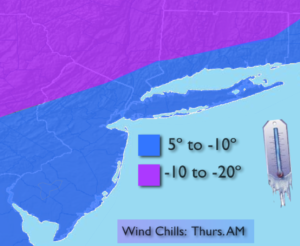
Partly sunny, windy and bitterly cold. Highs 8º to 12º above. Wind chills well below zero.
Saturday:
Partly sunny and bitterly cold. Highs within a few degrees of 10º.
Keep it here for a no nonsense, no hype forecast.