Synopsis:
The low that gave parts of the area some snow is moving out to sea. In its wake high pressure is moving in and will supply the region with cold readings through Thursday. Slick spots will be prevalent on surfaces that have been untreated. Please use caution overnight.
The high will become a mild weather maker Friday and into the weekend as it sets up shop over the Southeast. Skies will be mainly sunny the next several days.
Stay tuned.
Tonight:
Clearing and cold. Lows in the lower 20s in the City, the teens to near 10º inland. Northwest winds at 5-10mph.
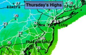
Thursday:
Partly sunny. Highs just above freezing. Northwest winds at 10-15mph.
Friday:
Partly sunny. Highs around 40º.
Saturday:
Partly sunny, milder. Highs in the mid to upper 40s.
Sunday:
Partly sunny. Mild. Highs in the upper 40s.
Monday:
Mostly cloudy with areas of drizzle or spotty showers. Highs in the mid 40s.
Keep it here for a no nonsense, no hype forecast.