Synopsis:
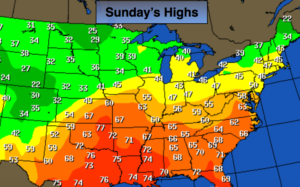
High pressure over the Southeast will continue to pump up mild air through today. The map above depicts just how mild the nation is. All of the Arctic air is banked up in Canada. Skies will feature a decent amount of sunshine and light winds.
A warm front will approach tonight and Monday with Grey skies and areas of drizzle or showers.
On Tuesday, ahead of a cold front, it will be mild with periods of rain.
More seasonal temperatures are expected for the later half of the workweek.
Looking down the pike no snowstorms are on the map at least through the next seven days.
Stay tuned.
Today:
Partly sunny. Mild. Highs in the mid to around 50º. Northwest to West winds at 5mph.
Tonight:
Mostly cloudy with areas of drizzle or patchy light rain after midnight. Lows in 30s throughout. Southwest to Southeast winds under 5mph.
Monday:
Cloudy with areas of drizzle or spotty showers. Highs in the lower to mid 40s.
Tuesday:
Rain through early afternoon. Some late afternoon sun. Mild. Highs in the lower to mid 50s.
Wednesday:
Partly sunny. Cooler. Highs around 40º.
Thursday:
Partly sunny. Cold. Highs in the mid 30s.
Keep it here for a no nonsense, no hype forecast.