Synopsis:
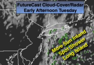
Tranquil conditions are expected for the week as high pressure systems dominate. The sun will return today although a weak trough of low pressure may keep the clouds and spotty showers over Long Island. Readings will be just below or near average for the week. The average high is in the mid 50s. A cool front will approach the area on Thursday. This system have limited moisture. A few showers are possible in the morning.
Looking down the pike, a significant cold front will move in later Saturday with rain. A cold blast will be with us for Sunday.
Stay tuned.
Today:
Mostly sunny inland. Mostly cloudy East of the City with spotty showers. Highs in the upper 40s. North wind at 5-10mph.
Tonight:
Partly cloudy. Lows in the upper 30s in the City the 20’s inland. North winds at at 5mph.
Wednesday:
Mostly sunny. Highs in the upper 40s.
Thursday:
A morning shower, otherwise, becoming partly sunny. Highs in the mid 50s.
Friday:
Mostly sunny. Highs in the mid to upper 40s.
Saturday:
Mostly cloudy with rain developing. Highs in the mid to upper 50s.
Keep it here for a no nonsense, no hype forecast.