Synopsis:
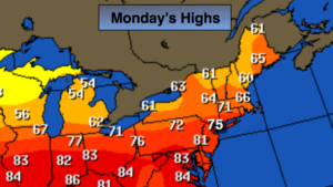
Just wait 24 hours and the weather will change- ain’t that the truth. We’ll go back to grey, cool and damp conditions for Columbus Day. Another high will move toward Northern New England today into tonight. This will once again result in a flow off the ocean with cloudy skies, spotty showers or areas of drizzle will return. Readings will be back to seasonal with highs within a few degrees of 70º.
This high looks to park itself over the off the Eastern Seaboard Tuesday and Wednesday resulting in above average temperatures and dry conditions. Any clouds on Tuesday will burn off and temperatures will once again pop to well above average readings. Wednesday will be Summer-like with highs around 80º. Both days will be humid.
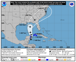
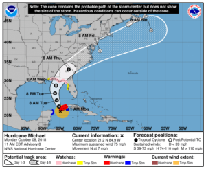
All eyes are strengthening Hurricane Michael. The hurricane should become a powerful Category 3 storm with winds near 120mph and making landfall Wednesday somewhere along the panhandle or big bend area of Florida (map above). Damaging winds and flooding rains are likely.
By Thursday, a cold font will be approaching the region. Showers and thunderstorms are likely. If Michael moves far enough North the storm will enhance our rainfall and gusty winds could occur especially at the coast. It’s way too early to get into specifics, but be aware that the potential for a period of heavy rain is possible later Thursday into Friday morning.
You know where to find a no hype, no nonsense forecast.
Stay tuned.
Columbus Day:
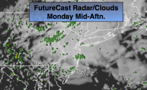
Cloudy with scattered showers or areas of drizzle. Less humid. Highs around 70º. East winds at 5-10mph.
Tonight:
Cloudy with areas of drizzle. Lows in the mid 60s in the City, around 60º inland. East to Southeast winds less than 5mph.
Tuesday:
AM Clouds and spotty drizzle to some sun. Warm & humid. Highs near 80º.
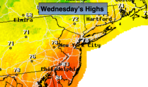
Wednesday:
Mostly sunny. Warm & humid. Highs near 80º.
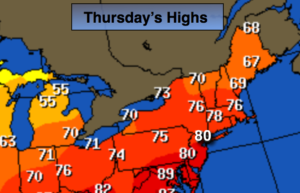
Thursday:
Mostly cloudy with scattered showers and storms likely. Humid. Highs in the mid 70s.
Friday:
The threat of morning rain. Cooler and much less humid. Highs in the mid to upper 60s.
Keep it here for a no nonsense, no hype forecast.