Synopsis:
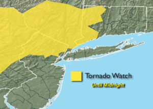
***Tornado Watch for areas North and West of NYC through Midnight*** Any severe thunderstorms that develop have the potential to produce a tornado. A watch means just that we “watch the situation”. If a tornado warning is issued for your area please seek shelter immediately.
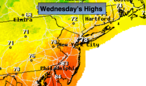
A weak cool front will approach this evening. Scattered showers and storms will occur through early tonight. A few of the storm s maybe strong to severe. Please keep an eye to the sky for threatening weather. The front (more like a humidity buster, rather than a cool front) will usher in a much less humid airmass for Wednesday. Readings will still be about ten degrees above the average high of 69º as there is no cool air behind the front. Readings on Thursday will top 80º in most areas ahead of another cool front. This front will be more significant and bring down temperatures to more seasonal levels Friday and Saturday. It’ll finally feel like Fall as high pressure over Eastern Canada dominates.
The high pressure will move over the region and offshore Sunday. Temperatures will pop once again to well above the average highs as winds begin to turn to a Southerly direction. This high looks to park itself over the Eastern Seaboard into next week resulting in well above average temperatures and dry conditions.
You know where to find a no hype, no nonsense forecast.
Stay tuned.
Tonight:
Scattered showers and storms early (some of the storms maybe strong to severe) otherwise, partly cloudy. Lows in the mid 60s in the City, the upper 50s inland. Southwest to Northwest wind under 5mph.
Wednesday:
Mostly sunny, warm but much less humid. Highs in the upper 70s. Northwest to North winds at 5-10mph.
Thursday:
Partly sunny and warm. Highs in the lower 80s.
Friday:
Partly sunny, much cooler. Highs around 70º.
Saturday:
Mostly sunny. Seasonal. Highs around 70º.
Sunday:
Mostly sunny, much warmer. Highs in the upper 70s.
Keep it here for a no nonsense, no hype forecast.