Synopsis:
High pressure off the Mid-Atantic coast will pump a warm and moderately humid airmass today. A mix of sun and clouds is expected. A weak cool front will approach later in the day and at night. Scattered showers and storms are p0ssible later in the day, but the greatest chance is during the evening. It’ll be warm with readings almost ten degrees above average. The average high is 69º. Another high will move in for the middle and end of the week. Above normal temperatures can be expected with a mix of sun and clouds. Temperatures will most likely crack 80º Wednesday and or Thursday.
The Autumn chill is banked up in Canada and won’t be heading our way anytime soon.
You know where to find a no hype, no nonsense forecast.
Stay tuned.
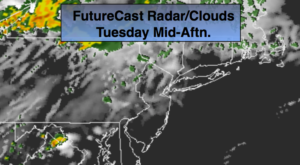
Today:
Sun giving way to clouds. Warmer. Scattered late day showers or storms are possible. Highs near 80º. South to Southwest winds at 5-10mph.
Tonight:
Scattered showers and storms early otherwise, partly cloudy. Lows in the mid 60s in the City, the upper 50s inland. Southwest to West wind under 5mph.
Wednesday:
Partly sunny. Warm. Highs near 80º.
Thursday:
Partly sunny and warm. Highs in the lower 80s.
Friday:
Partly sunny, mild. Highs in the mid 70s.
Saturday:
Mostly sunny, cooler. Highs in the lower 70s.
Keep it here for a no nonsense, no hype forecast.