Synopsis:
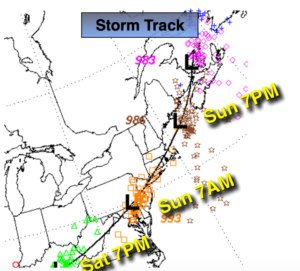
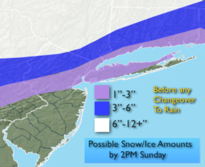
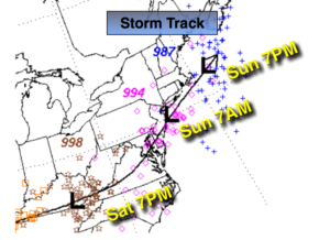
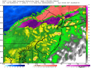
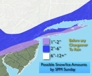
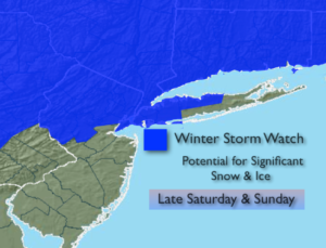
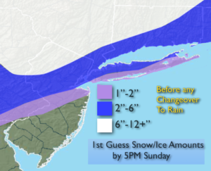
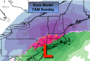
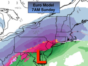
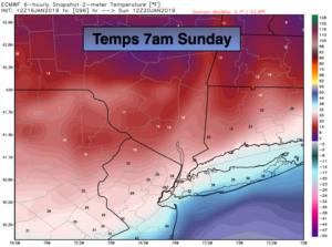
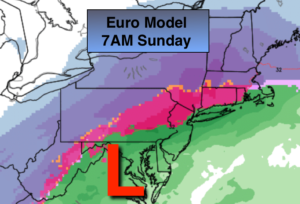
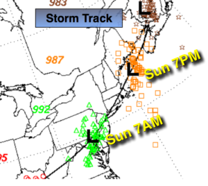
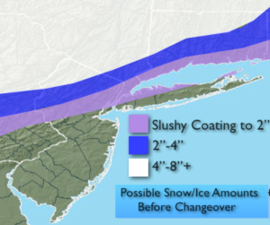
A storm will move from Northern West Virginia tonight to near Philadelphia by Sunday morning (first map above). Snow or a mix to the South will move in this evening. An accumulating snow (a couple to several inches depending on location) is likely just inland and including the City before a mix occurs tonight. A warm slug of air will work in changing the snow over the rain along the coast and a mix of freezing rain, sleet and or rain well inland. All of the latest computer guidance has a stronger storm, a warmer solution and a track that will kill the significant snowfall for NYC and the immediate vicinity. This warmup will occur for about 8 hours into early Sunday morning.
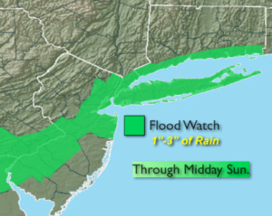
Freezing rain is possible where the temperatures remain near freezing later tonight. This will occur well inland, elsewhere heavy rain is expected. One to three inches of rain is possible. A Flood Watch has been posted for NYC, parts of NJ and coastal Connecticut (map above). If you encounter a flooded roadway-TURN AROUND, DON’T DROWN.
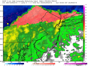
A flash freeze is likely on Sunday as the push of Arctic air works in. Heavy rain for most areas with a mix inland will taper off within a few hours of midday. By the time the Arctic air reaches the coast most of the precipitation will have moved East, so the change back to snow has diminished considerably. The sun will most likely return on Sunday for a part of the afternoon. All standing water or slushy will freeze solid.
Temperatures will plummet to the single digits throughout the region Sunday night as a bitterly cold airmass works in from Canada. Highs on Monday-Martin Luther King Jr. Day, will be only in the teens. The wind will add to the brutal conditions. Winds chills will be near 0º to -10º.
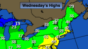
A January thaw is expected Wednesday into Thursday with showers likely.
You know where to find a no hype, no nonsense forecast.
Stay tuned.
Tonight:
Snow, heavy at times inland for a few hours than a transition over to a mix. Along the coast any mixed precipitation will go over to heavy rain. Lows rising into the 30s inland. Temperatures rising into the 30s and 40s along the coast and to the South. East winds increasing to 10-20mph.
Sunday:
Heavy rain during the morning. Mixed precipitation possible well inland. All precipitation will taper off around midday. Readings in the 30s & 40s depending on location. Temperatures will plummet to the teens and 20s later in the day. The sun will return for a portion of the afternoon. Southwest to Northwest winds increasing to 15-30mph.
Monday:
Partly sunny, windy and bitterly cold. Highs only in the lower to mid teens. Wind chills near 0º.
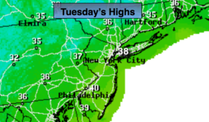
Tuesday:
Sunny and cold. Highs in the upper 20s.
Wednesday:
Mostly cloudy and much milder. Chance of showers. Highs in the mid 40s.
Thursday:
Mostly cloudy. Rain likely. Highs in the upper 40s.