Synopsis:
Today will start off with clouds and possibly some drizzle with the flow off the ocean as high pressure over New England influences the region. It’ll be much cooler. The sun will make an appearance during the afternoon. Inland areas maybe stuck with the clouds most of the day.
It will be unsettled into the weekend. An area of low pressure and it’s associated fronts will move over the Northeast Thursday through Sunday. The system will be a slow mover. Showers are possible just about anytime as we turn the calendar to June. It will not be a washout. There will be dry times.
Stay tuned.
Today:
Morning clouds, patchy fog will give way to some sun. Cooler. Highs in the mid 70s. East to Southeast winds at 5-10kmph.
Tonight:
Mostly cloudy with patchy fog and scattered showers. Areas of drizzle developing. Lows near 60º in the City, the upper 50s inland. East winds less than 5-10mph.
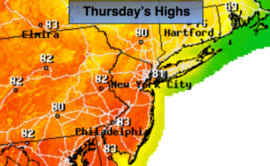
Thursday:
Mostly cloudy. Chance of showers. Highs around 70º.
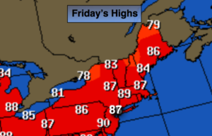
Friday:
More clouds than sun. Scattered showers and storms. Highs near 80º.
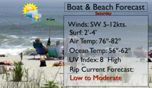
Saturday:
More clouds than sun. Chance of showers. Highs in the 70s.
Sunday:
Mostly cloudy, cooler. Chance of showers. Highs in the upper 60s.
Keep it here for a no nonsense, no hype forecast.