Synopsis:
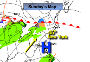
Much colder temperatures will be with us as an airmass pushes in from Canada this weekend. The culprit-high pressure moving in from the Great Lakes. Readings will be near freezing with a biting wind today despite the sunny skies. Wind Chills will be in the teens and 20s. It’ll be clear and cold tonight with diminishing winds. Sunday will feature sun giving way to clouds with not as harsh conditions.
Snow showers are possible Sunday night with a weak disturbance rapidly moving through. Many areas North of the City won’t see a flake. A dusting to a coating of snow is possible South of the City.
Monday will be partly sunny an another high pressure system influences our weather from Eastern Canada.
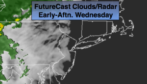
Looking ahead there will be a complex area of low pressure moving through the Eastern states Tuesday and Wednesday. Arctic air will be to our North, but like so many times this season low pressure will move to our West allowing mild air to work up from the South. The potential is there for a quick hit of snow late Monday night and Tuesday morning. The snow looks to go over to rain during the day along the coast. Inland, snow will transition to sleet and freezing rain and then eventually to rain. Some accumulation of snow is possible inland before the changeover.
You know where to find a no hype, no nonsense forecast.
Stay tuned.
Today:
Sunny, breezy and cold. Highs around freezing. Northwest winds at 15-25mph with gusts to 30ph. Windchills in the 20s.
Tonight:
Clear and cold. Lows in the lower 20s in the City, the teens inland. Northwest winds at 8-12mph.
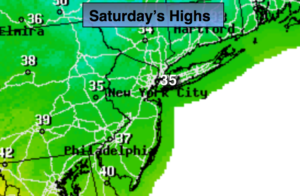
Sunday:
Clouds and sun. Highs in the mid to upper 30s.
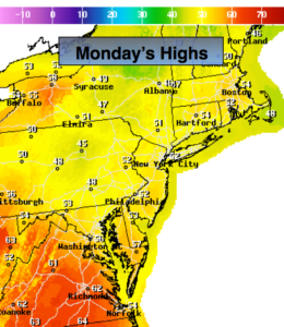
Monday:
Partly sunny. Highs in the mid to upper 30s.
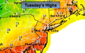
Tuesday:
Snow, mix, rain likely. Highs in the mid to upper 30s, closer to freezing well inland.
Wednesday:
Partly sunny. Highs in the lower to mid 40s.