Synopsis:
The weekend will be tranquil under a mix of sun and clouds as high pressure dominates. Today will be cold. Sunday’s readings will be several degrees above the average high of 37º.
Monday will be dry and chilly. There are signs that a storm may develop with a very deep trough in the East later Tuesday into Wednesday morning. The latest computer guidance suggests that the upper levels winds will be traveling at a very high speed, so even though a good bit of energy will swing through, precipitation looks to be limited. The storm won’t get it’s act together until it well to the North and East. At this time rain and snow showers are in the forecast for later Tuesday. A period of light snow is possible Tuesday night. Significant accumulations are not expected.
A bitter blast will once again grip the area on Wednesday and Thursday.
You know where to find a no hype, no nonsense forecast.
Stay tuned.
Today:
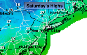
Partly sunny and cold. Highs around freezing. West to Southwest winds at 5-10mph.
Tonight:
Partly cloudy. Lows around 30º in the City, the 20s and teens elsewhere. Winds becoming Southeast at 5mph.
Sunday:
More clouds than sun. Milder. Highs in the lower 40s.
Monday:
Partly sunny and cold. Highs in the lower to mid 30s.
Tuesday:
Sun giving way to thickening clouds. Rain or snow showers are possible later in the day. Highs around 40º.
Wednesday:
Partly sunny, wind and very cold. Highs in the 20s with readings falling during the day.