Synopsis:
High pressure will move off the coast today. Readings will be several degrees above the average high of 37º. Clouds will dominate as a cold front approaches the area.
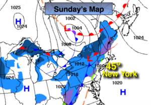
Monday will be dry and chilly. A polar vortex will swing out of Canada and move to the Great Lakes Tuesday and Wednesday. This airmass will be bitterly cold. The latest computer guidance suggests that the upper levels winds will be traveling at a very high speed, so even though a good bit of energy will swing through the area, precipitation looks to be limited for later Tuesday and Tuesday night. A storm won’t get it’s act together until it’s well to the North and East of the area. At this time rain and snow showers are in the forecast for later Tuesday. A period of light snow is possible Tuesday night. Minor accumulations are possible, mainly to the North and West of the City.
A bitter blast will once again grip the area on Wednesday and Thursday as the polar vortex pushes it’s Arctic grip on the tri-state area. Temperatures maybe as cold or even a tad colder the MLK’s frigid readings.
You know where to find a no hype, no nonsense forecast.
Stay tuned.
Today:
More clouds than sun. Milder. Highs in the mid 40s. Southeast to Southwest winds at 10-15mph.
Tonight:
Partly cloudy. Colder. Lows in the upper 20s in the City, the 20s and teens elsewhere. Northwest winds at 8-12mph.
Monday:
Partly sunny and cold. Highs in the lower to mid 30s.
Tuesday:
Mostly cloudy. Rain or snow showers are possible later in the day. Highs around 40º.
Wednesday:
Morning flurries, otherwise partly sunny, wind and very cold. Highs in the 20s with readings falling during the day.
Thursday:
Partly sunny and frigid. Highs 8º to 14º.