Synopsis:
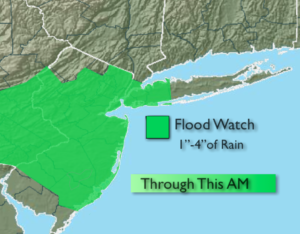
A Flash Flood Watch is in effect through this morning for the NYC vicinity and much of NJ. A slow moving cool front has produced torrential rain, flooding rain over parts of the watch area this morning. One to four inches of rain is possible within parts of the Watch area. If you see a flooded roadway, TURN AROUND, DON’T DROWN.
The steadiest rain will taper off toward mid-day. On and off showers are expected during the afternoon. Readings will be at least twenty degrees cooler than Saturday’s upper 80s.
On and off showers will continue tonight.
The Memorial Day forecast is still looking half way decent. The front should be just far enough South of the area for only the threat of a spot shower in the morning. Clouds should give way to some sun by afternoon. Temperatures will be a few degrees below the average high of 74º.
The beginning of the workweek will be warm with plenty of sunshine.
Stay tuned.
Today:
Heavy rain and thunderstorms this morning from the NYC vicinity South into NJ. The rain will taper off to scattered showers this afternoon. Highs only in the 60s. Northeast winds at 10-15mph.
Tonight:
Scattered showers. Lows in the 50s throughout. Northeast winds less than 5mph.
Memorial Day:
Clouds to some sun. A spot shower is possible in the morning. Highs around 70º.
Tuesday:
Partly sunny and warm. Highs in the mid 80s.
Wednesday:
Mostly sunny. Highs in the mid to upper 70s.
Thursday:
More clouds than sun Highs in the mid to upper 70s.
Keep it here for a no nonsense, no hype forecast.