Synopsis:
High pressure will build along the East coast for the remainder for today and the beginning of the Memorial Day Weekend. This high will become a warm weather maker. Skies will be mainly sunny with readings above average into Saturday. It’ll be a Summer preview.
By Sunday, a cool front will slip to our South. The threat of scattered showers is in the forecast at this time, but it doesn’t look like a washout. It’ll be much cooler.
Memorial Day is looking up! The front should be just far enough South of the area for only the threat of a spot shower. A mix of sun and clouds is expected with seasonal readings.
Please slather on the sunscreen, as this is most likely the first prolonged time much of us will be out in the sun. The UV index will be a high 8 through Saturday.
Stay tuned.
Today:
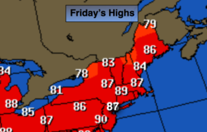
Sunny. Warmer. Highs in the mid to upper 80s. Southwest winds at 10-20mph.
Tonight:
Clear and much milder than recent nights. Lows around 70º in the City, the 60s inland. Southwest winds 5-10mph.
Saturday:
Partly sunny, very warm and more humid. An isolated afternoon storm is possible, especially inland. Highs in the mid to upper 80s.
Sunday:
Mostly cloudy, much cooler. Scattered showers, especially in the morning. Highs around 70º.
Memorial Day:
Sun and clouds. A spot shower is possible. Highs in the lower to mid 70s.
Tuesday:
Partly sunny and warm. Highs in the lower 80s.
Keep it here for a no nonsense, no hype forecast.