Synopsis:
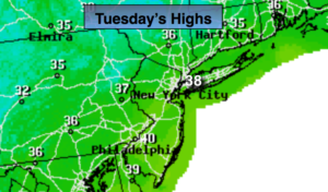
The next two days will be bright with moderating temperatures as high pressure works in from the West. Readings will be near the seasonal average of 38º today and rise to a few degrees above average tomorrow. A cold front will pass Wednesday night with the thermometer falling to near freezing for highs on Thursday.
A weak disturbance will move in on Thursday night and Friday morning with scattered areas of light snow and rain. A coating to a couple of inches is possible by Friday morning, mainly from the City and to the North and West.
Now on to the weekend. The latest computer guidance suggests the weekend will start off dry. The potential for a heavy precipitation event in the East starting later Saturday and into Sunday continues to increase. It should start as snow or a mix later Saturday afternoon. There is now a high possibility, looking at the latest computer models, that the snow/mix will go over to rain along the coast Saturday night and Sunday morning. Even inland the potential for change to rain is quite possible. The storm looks to take a track from the Ohio Valley to very near or right over the region on Sunday. This will draw up warmer air from the South and keep a majority of the event rain. There will be an incredibly tight thermal gradient along the East coast. A shift of 50 miles either way would be the difference between mostly rain or mostly snow and ice. This has to be watched, but as of today the warmer solution looks to win the battle.
A flash freeze is likely on Sunday as the push of Arctic air works in. Any leftover precipitation may go over to a period of snow on Sunday.
To recap: As of right now, it looks like a warmer solution resulting in the bulk of the heaviest precipitation being rain with wintry precipitation to start and to Finish. Obviously, this is not etched in stone as the storm is still 4 days away.
You know where to find a no hype, no nonsense forecast.
Stay tuned.
Today:
Mostly sunny. Highs in the upper 30s. Northwest winds at 5-10mph.
Tonight:
Mostly clear. Lows around 30º in the City, the teens inland. West winds at 5mph.
Wednesday:
Partly sunny. Highs in the lower 40s.
Thursday:
Sun to clouds. Colder. Highs in the lower to mid 30s.
Friday:
Mostly cloudy with scattered rain or snow showers in the morning. Milder. Highs in the lower 40s.
Saturday:
Morning sun will give way to thickening clouds. Snow will move in during the afternoon. A mix is possible over Southern areas. Highs around freezing.