Synopsis:
Three systems will affect the region the next four days. Two will be minor, the last could be more significant.
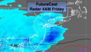
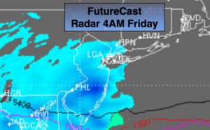
Tonight and early Friday morning, another weak disturbance (system #1) will skirt the area from the South. A period of light snow or snow showers is expected-FutureCast radar above. A coating to an inch is possible. Up to two inches of snow may accumulate over Ocean county. The light snow will end during the morning hours. Skies will remain mostly cloudy for the first day of March.
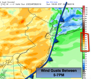
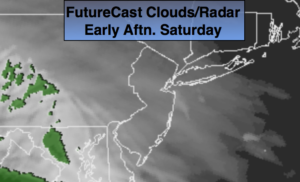
System #2 will affect the area Friday Night and Saturday morning as a low develops off the coast. Another coating is possible, but areas to the North and East of NYC may receive 1″-4″. The jackpot zone looks to be Eastern Connecticut.
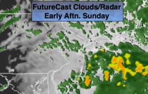
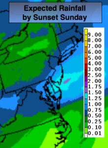
Sunday will start off with sun, but clouds will increase and thicken during the day. A storm will track up from the South (system 3). Showers are likely to develop during the afternoon. The track of the storm looks to run from just South of Washington, DC to Southern NJ to Eastern Long Island. The storm will be progressive, meaning it’ll move quickly. The storm is also loaded with moisture. A shot of moderate to heavy precipitation is expected for 6 hours Sunday night. The million dollar question is where will the rain, snow line setup? At this point in time areas North and West of NYC have the best chance of seeing significant snow. Closer to the coast it’ll be just warm enough for a mix, but I can’t rule out a changeover to snow here either. The storm will move away early Monday with any snow or mix ending during the early morning. Stay tuned.
Keep it here for a no nonsense, no hype forecast.
Tonight:
Cloudy. Light snow will develop after midnight. Lows in the upper 20s in the city, the teens inland. Northeast winds at 5mph.
Friday:
Early morning light snow, otherwise remaining cloudy. Highs around 40º. Northeast to East winds at 5-10mph.
Saturday:
Morning light snow or a mix. Heavier snow/mix possible for a time North and East of NYC. Highs around 40º.
Sunday:
Morning sun, otherwise thickening clouds with showers developing during the afternoon. Highs in the lower 40s. At this time, rain or a mix is possible at the coast at night. A mix to snow is possible inland.
Monday:
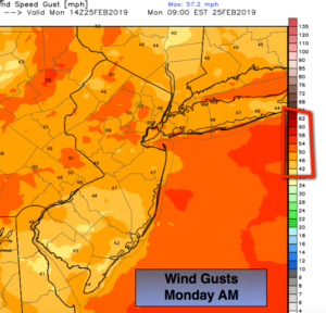
Early morning snow/mix, otherwise party sunny, wind and cold. Highs in the mid 30s.
Tuesday:
Partly sunny, breezy and cold. Highs around 30º.