Synopsis:
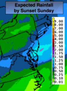
A low will move toward the region tonight and Sunday with rain. This is a familiar storm track for this Winter as the main low will pass well to the West allowing for mild temperatures and rain. Showers will develop during the evening. The rain will get steadier and heavier overnight and Sunday morning. The heaviest rain looks to fall along the coast where up to an inch or so may fall (1st map above). The rain will taper off midday Sunday and the sun should make an appearance during the late afternoon. It’ll be mild by days end with highs reaching the 40s inland and the lower 50s at the coast.
High winds will be the top story Monday. This is the result of strong low pressure in Eastern Canada and strong high pressure over the Northern Plains. The difference in pressure will cause strong Northwest winds that will possibly gust above 50mph at times.
The winds will abate Tuesday. It’ll be tranquil and chilly through midweek. In fact, it looks quiet through Friday as high pressure influences our weather. Temperatures will be below average as the high remains to the North.
Keep it here for a no nonsense, no hype forecast.
Tonight:
Scattered showers developing between 7pm-10pm. The rain will become steadier and heavier overnight. Lows rising into the 40s in the City and along the coast, rising through the 30s inland. Northwest to Northeast winds less than 5mph.
Sunday:
Rain likely through midday. Becoming partly sunny later in the day. Mild. Winds will increase dramatically toward sunset. Highs in the lower 50s. East to Southwest winds at 5-10mph.
Monday:
Partly Sunny and windy. Winds gusts above 50mph are possible. Highs in the lower 40s.
Tuesday:
Mostly sunny. Chilly. Highs in the mid 30s.
Wednesday:
Mostly sunny. Cold. Highs around freezing.
Thursday:
Sunny. Chilly. Highs in the upper 30s.