Synopsis:
High pressure move off the coast today. Clouds will dominate and any glimpse of sun will occur in the morning. Temperatures will be near the seasonal averages for this time of the year-the lower to mid 40s.
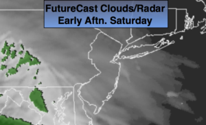
A low will move toward the region tonight and Sunday morning with rain. This is a familiar storm track for this Winter as the main low will pass well to the West allowing for mild temperatures and rain. The rain will end midday Sunday and the sun should make an appearance during the afternoon. More than an inch of rain is possible.
The beginning of next week will be seasonally cold. High winds will be the top story Monday.
The winds will abate Tuesday. It’ll be tranquil and chilly through midweek. In fact, it looks quiet through Friday as high pressure influences our weather.
Keep it here for a no nonsense, no hype forecast.
Today:
Mostly cloudy. Highs in the mid 40s. Northeast to Southeast winds at 5-10mph.
Tonight:
Rain developing between 7pm-10pm. Lows rising into the 40s in the City and along the coast, rising through the 30s inland. Northwest to Northeast winds less than 5mph.
Sunday:
Rain likely through midday. Becoming partly sunny later in the day. Mild. Winds will increase dramatically toward sunset. Highs in the mid 50s.
Monday:
Partly Sunny and windy. Highs in around 40º.
Tuesday:
Partly Sunny. Chilly. Highs in the mid 30s.
Wednesday:
Partly Sunny. Chilly. Highs in the mid 30s.