Synopsis:
Weather systems will remain weak this upcoming week. Despite that the much of the country is hot, including our area. The heat will be on through the upcoming week. Temperatures will flirt with 90º through Friday. Hazy sun is expected much of the time with moderate to high levels of humidity. Isolated afternoon storms are possible. Typical July conditions.
Stay Tuned.
Keep it here for a no nonsense, no hype forecast.
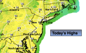
Today:
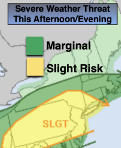
Partly sunny and hot. Isolated afternoon storms. Highs in the lower 90s. Cooler at the coast. Northeast to Southeast winds at 5-10mph.
Tonight:
Isolated storms this evening, otherwise partly cloudy. Lows around 70º in the City, the 60s inland. Light Southeast winds.
Tuesday:
Hazy, warm and humid. Isolated afternoon storms. Highs in the mid 80s.
Wednesday:
Hazy, hot and humid. Isolated afternoon storms. Highs in the upper 80s.
Thursday:
Hazy, hot and humid. Highs in the lower 90s.
Friday:
Hazy, warm and humid. Isolated afternoon storms. Highs in the upper 80s