Synopsis:
June’s Debut will feature the same conditions as May’s Finale yesterday-cool sunshine. Temperatures will be several degrees below the average high of 75º.
High pressure will settle over the Southeast by midweek. This setup will result in moderating temperatures. Comfortable conditions will be with us on Tuesday. By Wednesday, a warm front will move through in the morning. A push of very warm and humid airmass will be experienced once the front moves through. It will be uncomfortable. An impulse will head our way from the West later in the day. This will lead to a threat of afternoon storms. Readings will remain in the 80s through the end of the week with lower humidity.
Stay Tuned.
Keep it here for a no nonsense, no hype forecast.
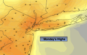
Today:
Mostly sunny. Highs in the 60s to around 70º in the City. Northwest winds at 8-12mph.
Tonight:
Partly cloudy. Lows in the upper 50s along the urban corridor, the upper 40s and 50s inland. West winds 5-10mph.
Tuesday:
Partly sunny. Highs in the lower 70s.
Wednesday:
Partly sunny. Warmer and more humid. Chance of afternoon storms. Highs in the mid 80s.
Thursday:
Partly sunny. Less humid. Highs in the mid 80s.
Friday:
Partly sunny. Highs in the lower 80s.