Synopsis:
The clouds and sun will battle it out today as a weakening disturbance moves in from the West. Highs will be just below the normal highs of the mid 70s.
Tonight a warm front will move into the area. Showers and possibly a thunderstorm is possible. A warm and humid airmass will move in for Wednesday. It will be uncomfortable, especially from the City and to the South. An impulse will head our way from the West later in the day. This will lead to a threat of afternoon storms. The greatest chance is from the City and to the South and West.
Readings will remain in the 80s through the end of the week with lower humidity. A slight shower chance will be included for Friday, but much of the day should be dry.
Saturday will be cooler behind a cold front. The sun will dominate.
Stay Tuned.
Keep it here for a no nonsense, no hype forecast.
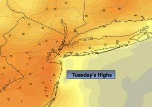
Today:
Clouds, some sun. Highs in the lower 70s. West to Southwest winds at 5-10mph.
Tonight:
Mostly cloudy with scattered showers and possibly a thunderstorm. Lows 60º-65º throughout. Southwest winds 5mph.
Wednesday:
Partly sunny. Warmer and more humid. Chance of afternoon storms. Highs in the mid 80s. Cooler to the North.
Thursday:
Partly sunny. Less humid. Highs in the mid 80s.
Friday:
Partly sunny. Chance of a shower. Highs in the lower 80s.
Saturday:
Partly sunny. Highs in the mid 70s to around 80º.