
Synopsis:
As we turn the page to August today the adjective to describe the weather is spectacular. It will warm and sunny with low levels of humidity. Tonight and Sunday will feature a push of tropical air from the South. This will result in high humidity and spotty showers and storms through Sunday. It will not be a washout.
All eyes then turn to Hurricane Isaias. The storm will head through the Bahamas today. Confidence continues to increase that Isaias will move along the Florida coast on Sunday as a category one hurricane. Whether Isaias is a minimal hurricane or tropical storm; it will ride along the coast (either just inland or along) and most likely affect our area on Tuesday. By that time the storm will be rapidly moving. The potential is there for areas of heavy rain and gusty winds. The specifics will be fine-tuned as the even nears. High surf and beach erosion will occur.
The storm will move out of the area on Wednesday and the sun will return.
Stay Tuned.
Keep it here for a no nonsense, no hype forecast.
Today:
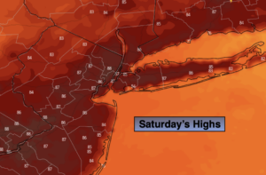
Mostly sunny and warm. Highs in the mid to upper 80s. Northeast to Southeast 5-10mph.
Tonight:
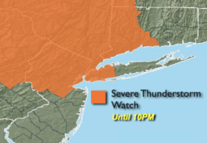
Becoming mostly cloudy and muggy. Isolated showers or storms. Lows in the mid 70s in urban areas, the upper 60s to near 70º inland. Southeast wind less than 5mph.
Sunday:
Mostly cloudy with spotty showers and storms in the morning. Some hazy afternoon sun with scattered storms. Very humid. Highs in the mid 80s.
Monday:
Hazy, warm and humid. Chance of afternoon scattered showers and storms. Highs in the mid to upper 80s.
Tuesday:
Potential for area of heavy rain and gusty winds. Humid. Highs in the upper 70s.
Wednesday:
Partly sunny. Highs in the mid to upper 80s.