Synopsis:
High pressure will be in control of our weather through Thursday. This will result is bright, comfortable days and mainly clear, cool nights.
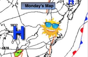
The beginning and middle portion will feature mainly sunny skies with slowly moderating temperatures as a strong area of high pressure moves from Southeastern Canada to off the Northeast coast. The humidity will be a low levels.
The next chance of showers will be Friday as the wind turns to the South and moisture rides up and around the offshore high pressure. It also be more humid.
Stay Tuned.
Keep it here for a no nonsense, no hype forecast.
Today:
Sunny. Highs in the mid 70s. Northeast to Southeast winds at 5-10mph.
Tonight:
Mostly clear and cool. Lows around 60º in the City, the upper 40s and 50s inland. Southeast to Northeast winds less than 5mph.
Tuesday:
Sunny. Highs in the upper 70s.
Wednesday:
Mostly sunny. Highs around 80º.
Thursday:
Partly sunny. Highs in the lower 80s.
Friday:
Sun and clouds. Scattered showers, more humid. Highs in the mid 80s.