Synopsis:
High pressure that gave us two days of splendid June conditions will move off the coast and allow for a warmer Southwesterly flow the next 48 hours. Temperatures will get several degrees above the average high and pop well into the 80s. Plenty of sunshine is expected through Wednesday.
The next chance of showers will be with an approaching front on Thursday.
The sun will return on Friday along with warm temperatures. The weekend looks decent with tolerable temperatures and humidity under a mix of sun and clouds.
Stay Tuned.
Keep it here for a no nonsense, no hype forecast.
Today:
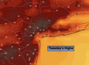
Sunny. Much warmer. Highs in the mid to upper 80s. Cooler at the coast. Northwest to South winds at 5-10mph gusting up to 20mph at times during the afternoon.
Tonight:
Mostly clear. Not as cool as recent nights. Lows around 70º in the City, the 60s inland. Southwest to Southeast winds 5mph.
Wednesday:
Partly sunny. More humid. Highs in the mid 80s.
Thursday:
Clouds, some sun. Humid. Chance of showers. Highs around 80º.
Friday
Mostly sunny. Warm. Highs in the mid 80s.
Saturday
Partly sunny. Highs in the lower 80s.