Synopsis:
High pressure over the Western Atlantic will result in a Southerly flow of warm and more humid air through Thursday. A mix of sun and clouds is expected today. An isolated thunderstorm is possible during the afternoon over Western sections.
Scattered showers and storms are likely tonight as a weak disturbance rides through the tri-state area. It will be warm and muggy.
A cool front will approach on Thursday with scattered showers and isolated storms. Temperatures will be near the seasonal average of 79º.
The sun will return on Friday along with warm temperatures. The weekend looks decent with tolerable temperatures and humidity under a mix of sun and clouds as high pressure noses in from Canada.
Stay Tuned.
Keep it here for a no nonsense, no hype forecast.
Today:
Partly sunny. An isolated storm is possible over Western areas. Humid. Highs in the mid 80s. Cooler at the coast. Southeast winds at 8-15mph.
Tonight:
Mostly cloudy with scattered showers and storms. Muggy and warm. Lows within a few degrees of 70 throughout. South winds at 8-12mph.
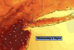
Thursday:
Clouds, some sun. Humid. Chance of showers and isolated storms. Highs around 80º.
Friday:
Mostly sunny. Warm. Highs in the lower to mid 80s.
Saturday:
Mostly sunny. Highs around 80º.
Sunday:
Partly sunny. Highs in the upper 70s.