Synopsis:
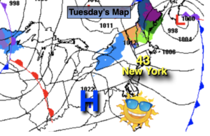
High pressure will move offshore today. This will result in a return Southwesterly flow and cause readings to start their climb to more tolerable levels. Highs will be a few degrees above the average of 42º. Sun and high clouds are expected.
Tonight will be much milder than recent nights. Lows will actually be near the average high for the date!
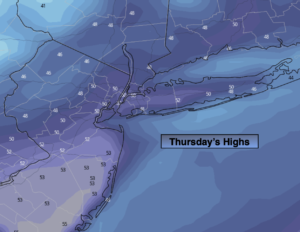
On Thursday, a deep Southerly flow will result in Spring-like readings under a mix of clouds and sun. Highs will be around 60º. Any showers should hold off until later Thursday evening as a significant front makes it’s approach.
Rain is likely Thursday night into early Friday morning as the front sweeps through. Readings on Friday will still be mild in the morning but temperatures will fall in the afternoon.
The Presidents’ Day holiday weekend looks bright and tranquil with near seasonal temperatures.
Stay tuned.
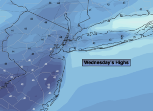
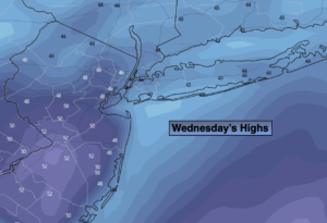
Wednesday:
Sun and high clouds. Milder. Highs in the mid 40s. South winds at 8-12mph.
Tonight:
Mostly cloudy. Much milder. Lows in the 40s throughout. Southwest winds at 5-10mph.
Thursday:
Mostly cloudy. Balmy. Showers possible by evening. Highs around 60º.
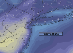
Friday:
Early morning rain, otherwise mostly sunny. Highs in the lower 50s. Temperatures will fall during the afternoon.
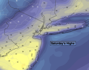
Saturday:
Mostly sunny. Highs in the mid 40s.
Sunday:
Sunny. Highs in the lower 40s.