Synopsis:
Our Spring preview will continue through Saturday as high pressure dominates over the Southeast. Bright, mild and tranquil conditions are expected. Temperatures will be well above the average high of 40º.
By Saturday evening, a cold front will swing through. We’ll be back to reality with Winter. Temperatures on Sunday will be well below the average high of 42º. An area of low pressure will develop on the offshore cold front. It looks like this will be a few hours of light snow. The greatest chance of a coating will be at the coast. Well inland it may not flake at all. This will not be a big deal.
Monday will be very cold with readings remain in the 20s as Arctic high pressure dominates.
By Tuesday many areas should approach or crack freezing under sunny skies.
Stay tuned.
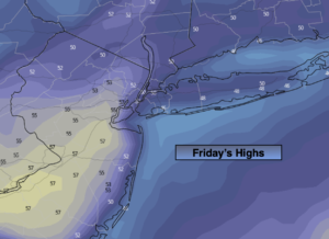
Friday:
Mostly sunny. Mild. Highs in the lower to mid 50s in the City. Cooler well inland and at the coast. South winds at 8-12mph.
Tonight:
Becoming mostly cloudy. Very mild. Lows will be warmer than the average high for the day!. Lows in the mid to upper 40s in urban areas, the upper 30s and 40s North and West. Southwest winds less than 5mph.
Saturday:
Clouds to sun. Spring-like. Highs in the mid 50s.
Sunday:
Mostly cloudy. Much colder. Potential for a period of light snow in the morning, especially at the coast. Highs in the lower 30s.
Monday:
Partly sunny, windy and very cold. Highs in the upper 20s.
Tuesday:
Sunny. Highs in the lower 30s.