Synopsis:
We are in for a Spring preview the next few days as high pressure dominates over the Southeast. Bright, mild and tranquil conditions are expected through Saturday. Temperatures will be well above the average high of 40º. A nice stretch for February!
By Saturday evening, a cold front will swing through. We’ll be back to reality with Winter. Temperatures on Sunday will be well below the average high of 42º. An area of low pressure will develop on the offshore cold front. If the low is close enough there is the potential for a period of snow, especially along the coast. This is no way etched in stone. It very well maybe dry and cold. Please keep it here for the very latest. How ever you slice it even if it does snow it shouldn’t be significant.
Monday will be very cold with readings remain in the 20s as Arctic high pressure dominates.
Stay tuned.
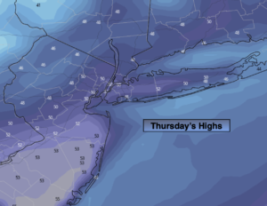
Thursday:
Mostly sunny. Milder. Highs in the 40s to around 50º. The lower 50s over Central NJ. Southwest winds at 8-12mph.
Tonight:
Clear to partly cloudy. Lows near 40º in urban areas, the 20s and 30s North and West. West winds less than 5mph.
Friday:
Mostly sunny. Highs in the upper 40s.
Saturday:
Partly sunny. Spring-like. Highs in the mid 50s.
Sunday:
Mostly cloudy. Much colder. A low potential for a period of snow. Highs in the lower 30s.
Monday:
Partly sunny, windy and very cold. Highs in the upper 20s.