Synopsis:
Low pressure will come a bit closer to the coast tonight on its way North. For this reason a period of rain is likely for most of the region. The Northwestern fringe of this could be mixed in with wet snow or sleet. Well North and West it will be mainly dry as the precipitation shield won’t get that far inland.
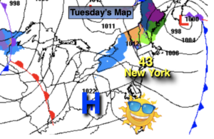
The storm will move well off our coast on Tuesday, any clouds and morning rain early east will give way to some sun. Temperatures will be a couple degrees above the average high of 40º.
Bright and tranquil conditions are expected for midweek to late as weak high pressure dominates. Temperatures will be well above the average high of 40º as no Arctic intrusions are expected. A nice stretch for February!
The start of the weekend will feel like Spring with readings getting into the 50s!
Stay tuned.
Tonight:
Rain for most areas. Wet snow and or sleet may fall for a time inland. Lows in the mid 30s in urban areas, the upper 20s North and West. North wind at 5-10mph.
Tuesday:
Early morning rain east, otherwise becoming partly sunny. Highs in the lower 40s.
Wednesday:
Partly sunny. Mild. Highs in the mid 40s.
Thursday:
Partly sunny. Milder. Highs in the mid 40s.
Friday:
Partly sunny. Mild. Highs in the upper 40s.
Saturday:
Partly sunny. Spring-like. Highs in the lower 50s.