Synopsis:
Today will be the last day of the heat wave. The humidity will be oppressive. Clouds and sun are expected. A passing shower is possible later in the morning. Scattered thunderstorms will develop this afternoon and move to the coast this evening. Some of the storms may turn severe. Damaging wind gusts are possible. Not all areas will be in on the action. Most regions would benefit greatly from any rain. Eye to the sky for threatening weather.
Relief from the heat will arrive on Tuesday behind the cool front. Listen, it won’t be 70º but anything is better than 100º. It’ll be a similar forecast for Wednesday.
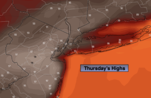
By Thursday the humidity will increase as a push of tropical air comes up from the South. Readings will approach 90º and there is a threat of a thunderstorm in the afternoon.
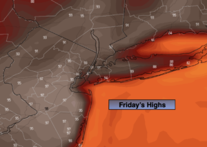
A cool front will approach Friday. It very well may come through fairly uneventful. At this time, a a few showers are possible under a mix of clouds and sun.
Stay tuned.
Keep it here for a no hype, no nonsense forecast.
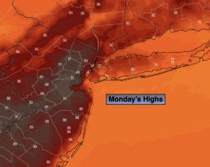
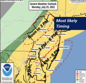
Monday:
Clouds and sun. Breezy. Spotty late morning shower. Hot and humid. Scattered afternoon storms. Highs 88º-95º. Heat index in urban areas near 100º. Southwest winds at 10-20mph with higher gusts.
Tonight:
An evening spotty storm East, otherwise partly cloudy. Much cooler than recent nights. Lows around 70º in urban areas, the 60s North and West. Winds becoming Northwest and diminishing to 5mph.
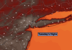
Tuesday:
Mostly sunny. Not as hot or humid. Highs in the mid 80s.
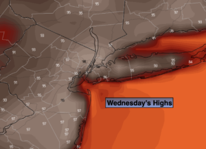
Wednesday:
Mostly sunny. Very warm. Highs in the upper 80s.
Thursday:
Clouds and sun. Very warm. More humid. Scattered afternoon showers or storms possible. Highs around 90º.
Friday:
Sun and clouds. Spotty showers possible. Highs in the upper 80s.
Catch me on the Fox Business Network from 6am to 9am Sunday and the Fox Weather Stream until 10am. Find us on Tubi, Roku TV and YouTube TV and as always the Fox Weather App. It’s Free!